Have you ever thought about what you would do if you were caught in the middle of a flash flood whilst driving? Or where you would go to get to safety when water is surrounding your home? Lenovo recognizes the critical role technology plays in disaster preparedness and wants to harness and empower entrepreneurs’ and charities’ technology and creative know-how to achieve better natural disaster preparedness, recovery, and resilience.
Each year, disasters around the world kill nearly 100,000 people and affect or displace 200 million people. Weather, climate, and water-related hazards account for at least half of all global disasters over the past 50 years, according to the United Nations’ World Meteorological Organization (WMO).
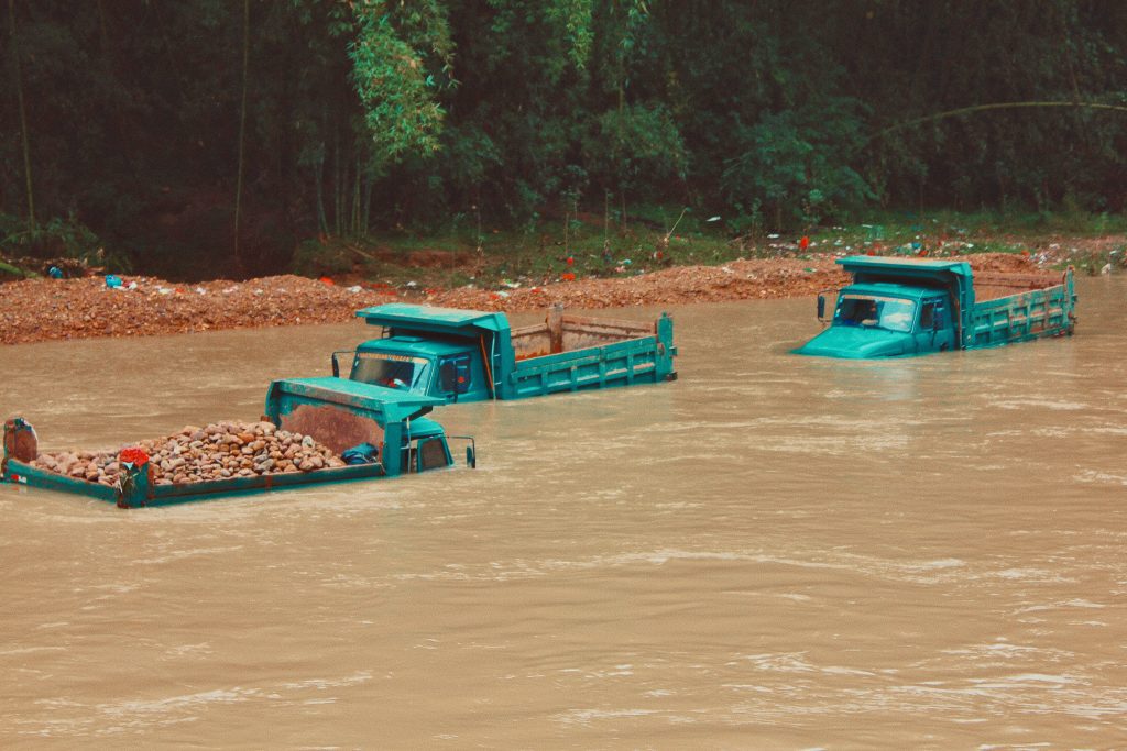
In the last few weeks, countries worldwide have been plagued by extreme weather conditions and intense rainfall, leading to flash floods in Singapore and China and severe flooding in the German states of North Rhine-Westphalia and Rhineland-Palatinate.
In a report launching in September, WMO found that water-related disasters have dominated in the last half-century, costing economies billions and killing thousands.
Harnessing technology to improve natural disaster preparedness
In recent years, the demands for disaster forecast and preparation have become critically important. As a result, we have seen a rise in entrepreneurs and charities creating technologies and solutions to achieve better natural disaster preparedness, recovery, and resilience.
One such organization is FloodMapp. An Australian-based startup that aims to wash out old approaches to hydrology and predictive analysis, creating a modern system to help emergency managers and citizens know when the floods are coming and what to do. Specializing in rapid real-time flood forecasting and flood inundation mapping, FloodMapp seeks to provide greater warning time that can potentially save lives and reduce damage and associated financial losses. Its real-time, area- and property-specific flood forecasts, maps and analysis aim to improve all phases of emergency management: before, during and after flooding.
Furthermore, through hourly updates of weather, coastal, and river system data, its street-to-flood navigation tool can be integrated into existing platforms. Including navigation apps like WAZE, which can give drivers live traffic routing updates and notifications. More recently, FloodMapp’s ability to quickly pull data allowed authorities in the Hawkesbury-Nepean region in New South Wales, Australia, to find 9,429 properties impacted by flooding.
Mapping Missing Areas
Floods have a devastating impact – ripping communities apart, wiping out neighborhoods, forcing the evacuation of thousands of people every year, and recovery is not always possible. Many places affected by flash floods and severe flooding are literally ‘missing’ from any map. More often than not, first responders lack the information to make valuable decisions regarding relief efforts. But Missing Maps is changing that.
An open, collaborative tool, Missing Maps seeks to map rural areas providing an overview of buildings, trees, and other data points that humanitarian organizations can use while trying to meet the needs of vulnerable people. Used by a collective of organizations, this tool enables them to carry out their own mapping activities with their wider communities guided by shared ethics.
Earlier this year, Lenovo AP’s eCommerce team participated in a team building “Missing Map-a-thon” event in collaboration with beneficiary partner Red Cross Crescent Society. This Map-a-thon provided Lenovo employees with the opportunity to digitally connect and create urgently needed data for communities in Banjarnegara North Province in Indonesia – an area prone to natural disasters such as landslides and earthquakes. Participants were tasked with assisting local first responders in forecasting and preparing effective disaster response and strengthening community resilience. The team generated 52.62 square kilometers of maps during this session, which will ultimately help local and international relief organizations better respond to crises affecting these areas and ensure the success of humanitarian initiatives.
How else is Lenovo delivering local response and relief to natural disasters?
As part of Lenovo’s pivot to virtual volunteerism during “Love On” Global Month of Service last year, Lenovo encouraged employees to participate in local virtual initiatives to ensure that the COVID-19 pandemic did not hinder their ability to give back to their community.
Even at the height of the pandemic, Lenovo’s volunteering programs continued to steadily grow as individuals across AP offices organized projects for their colleagues. For example, our teams in EMEA are currently running fundraising initiatives to provide relief to the flooding in Germany.
Earlier this year, Lenovo supported employees, partners, customers, and friends in their efforts to stay safe amid the latest, brutal wave of COVID 19. Through the Lenovo Foundation, Lenovo committed INR 80 million (approximately US$1 million) towards COVID-19 relief to meet India’s short-term and long-term requirements. Donations in medical equipment such as oxygen containers, refillable oxygen cylinders were made to hospitals where the need was high. In addition, hospital extensions were built to support medical frontline workers further.
You can read more articles on how Lenovo supports its communities through disaster relief here: